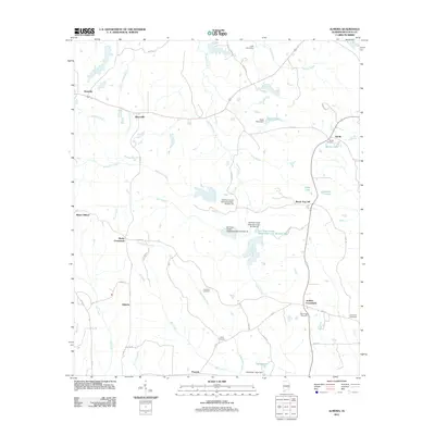
2011 Map of Almeria
USGS Topo · Published 2011About this map
Almeria and the rural surroundings of Bullock County are defined by a network of creeks and small settlements connected by county roads. Significant water management is evident through the series of Old Town Creek Watershed structures, including Old Town Creek Watershed Dam Number 24 and Old Town Creek Watershed Lake Number 26. The landscape transitions from the higher ground of Bread Tray Hill toward the many branches of Bughall Creek and Mill Creek. For genealogists and local historians, the map serves as a vital record of community anchors, documenting numerous burial grounds such as High Ridge Cemetery, Hubbard Cemetery, and Liberty Cemetery. These sites, along with hamlets like Hooks Crossroads and Bruceville, preserve the spatial history of this agricultural region as it appeared in the early 21st century.
Find a feature on this map
49 named features on this map. Tap any name to fly to it.
Don’t see what you’re looking for? This feature index may not catch every label — zoom into the map to look around manually.
Map Details
Editions of this 2011 Almeria Map
This is the sole edition of this map. No revisions or reprints were ever made.
Other maps of this area

1953 · Dothan
USGS Topo · 1:250,000

1954 · Dothan
USGS Topo · 1:250,000

1955 · Dothan
USGS Topo · 1:250,000

1955 · Phenix City
USGS Topo · 1:250,000

1957 · Phenix City
USGS Topo · 1:250,000

1958 · Phenix City
USGS Topo · 1:250,000

1968 · Perote
USGS Topo · 1:24,000
1968 · Saco
USGS Topo · 1:24,000
1968 · Needmore
USGS Topo · 1:24,000
1971 · China Grove
USGS Topo · 1:24,000