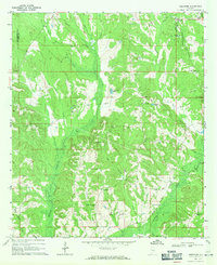
1968 Map of Needmore
USGS Topo · Published 1971About this map
Needmore serves as a central point in this late 1960s landscape, where the borders of Pike, Montgomery, and Bullock counties meet. The terrain is defined by a dense network of tributaries feeding into the Conecuh River, including Panther Creek and Mannings Creek. This survey captures a rural Alabama community structured around small settlements and spiritual centers such as Benevolent Grove Ch and Murphys Chapel.
Find a feature on this map
29 named features on this map. Tap any name to fly to it.
Don’t see what you’re looking for? This feature index may not catch every label — zoom into the map to look around manually.
Map Details
Editions of this 1968 Needmore Map
This is the sole edition of this map. No revisions or reprints were ever made.
Other maps of this area

1953 · Montgomery
USGS Topo · 1:250,000

1953 · Andalusia
USGS Topo · 1:250,000

1953 · Dothan
USGS Topo · 1:250,000

1954 · Dothan
USGS Topo · 1:250,000

1955 · Dothan
USGS Topo · 1:250,000

1955 · Phenix City
USGS Topo · 1:250,000

1956 · Montgomery
USGS Topo · 1:250,000

1957 · Phenix City
USGS Topo · 1:250,000

1957 · Montgomery
USGS Topo · 1:250,000

1957 · Andalusia
USGS Topo · 1:250,000