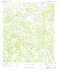
1971 Map of Almeria
USGS Topo · Published 1974About this map
Almeria and its surrounding rural landscape in Bullock County are defined by a network of small creeks and community crossroads. The area is heavily marked by local spiritual and familial history, featuring numerous country churches like Bethlehem Ch and Little Sardis Ch, alongside several burial grounds including Macedonia Cem and Hubbard Cem. The drainage patterns of Bughall Creek and Beaverdam Creek shape the terrain, which rises to a prominent feature simply labeled Mountain in the western section. Transportation is anchored by the C Of G railroad line in the southeast near Inverness, while numerous Sandpit locations suggest a local economy tied to the land's natural resources. Small settlements like Bruceville, Sardis, and Simsville remain connected by light-duty roads that weave through this wooded coastal plain environment.
Find a feature on this map
34 named features on this map. Tap any name to fly to it.
Don’t see what you’re looking for? This feature index may not catch every label — zoom into the map to look around manually.
Map Details
Editions of this 1971 Almeria Map
This is the sole edition of this map. No revisions or reprints were ever made.
Other maps of this area

1953 · Dothan
USGS Topo · 1:250,000

1954 · Dothan
USGS Topo · 1:250,000

1955 · Dothan
USGS Topo · 1:250,000

1955 · Phenix City
USGS Topo · 1:250,000

1957 · Phenix City
USGS Topo · 1:250,000

1958 · Phenix City
USGS Topo · 1:250,000

1968 · Perote
USGS Topo · 1:24,000
1968 · Saco
USGS Topo · 1:24,000
1968 · Needmore
USGS Topo · 1:24,000
1971 · China Grove
USGS Topo · 1:24,000