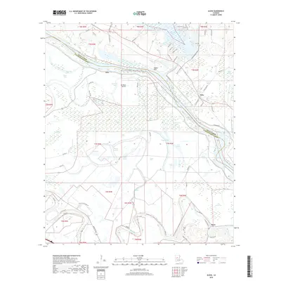
2018 Map of Aloha
USGS Topo · Published 2018About this map
The Red River carves a wide path through this central Louisiana landscape, defining the boundary between Grant Parish and Natchitoches Parish. The settlement of Aloha sits along the eastern bank, while Odra and Marco anchor the river's southern and western reaches. The terrain is characterized by a complex network of waterways, including Cane River and Bayou Cocodrie, interspersed with numerous oxbow lakes such as Lake Cocodrie and Big Trudo Lake. To the north, the Nantachie Dam holds back the waters of Nantachie Lake, surrounded by residential loops like Nantachie Acres. This 2018 survey reveals a landscape shaped by both natural river migration and human management, with low-lying areas like Ash Brake Bottom and the prominent Waddel Bluff providing distinct elevation changes. Local history is preserved at the Marce Cem, located near the winding course of the Cane River in the southern portion of the quadrangle.
Find a feature on this map
81 named features on this map. Tap any name to fly to it.
Don’t see what you’re looking for? This feature index may not catch every label — zoom into the map to look around manually.
Map Details
Editions of this 2018 Aloha Map
This is the sole edition of this map. No revisions or reprints were ever made.
Other maps of this area

1932 · Colfax SW
USGS Topo · 1:31,680

1932 · Colfax NW
USGS Topo · 1:31,680

1935 · Verda
USGS Topo · 1:31,680

1936 · Colfax
USGS Topo · 1:62,500

1937 · Chopin NE
USGS Topo · 1:31,680

1937 · Chopin NW
USGS Topo · 1:31,680

1937 · Aloha
USGS Topo · 1:31,680

1937 · Montgomery
USGS Topo · 1:62,500

1937 · Cloutierville
USGS Topo · 1:31,680

1941 · Boyce
USGS Topo · 1:62,500