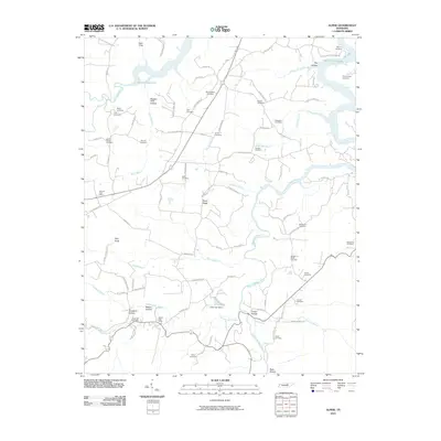
2010 Map of Alpine
USGS Topo · Published 2010About this map
Monroe Post Office and Alpine Post Office serve as central nodes in this rural Tennessee landscape, where the topography is defined by the winding West Fork Obey River and the southern reaches of Dale Hollow Lake. The map reveals a high density of family and community burial grounds, such as Smiths Chapel Cemetery, Regan Cemetery, and Winningham Cemetery, reflecting the deep ancestral roots of the local population. Landforms here are often identified by their relationship to the drainage system, with numerous named hollows like Bugger Hole Hollow, Means Hollow, and Cowan Hollow carving through the terrain. Evidence of water management and local landmarks appear at the Jolly Lake Dam on Jolly Lake, while the elevation rises toward Pilot Knob and Rocky Ridge, providing a detailed look at the interface between the Cumberland Plateau's geology and the early 21st-century rural road network.
Find a feature on this map
91 named features on this map. Tap any name to fly to it.
Don’t see what you’re looking for? This feature index may not catch every label — zoom into the map to look around manually.
Map Details
Editions of this 2010 Alpine Map
This is the sole edition of this map. No revisions or reprints were ever made.
Other maps of this area

1897 · Standingstone
USGS Topo · 1:125,000

1898 · Standingstone
USGS Topo · 1:125,000

1924 · Lillydale
USGS Topo · 1:62,500

1926 · Lillydale
USGS Topo · 1:62,500

1929 · Lillydale
USGS Topo · 1:62,500

1929 · Byrdstown
USGS Topo · 1:62,500

1944 · Livingston
USGS Topo · 1:24,000

1954 · Crawford
USGS Topo · 1:24,000
1955 · Livingston
USGS Topo · 1:24,000
1955 · Okalona
USGS Topo · 1:24,000