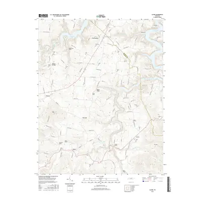
2016 Map of Alpine
USGS Topo · Published 2016About this map
Wirmingham and the nearby Ivyton settlement define this portion of the Highland Rim, where the land breaks toward the deep waters of Dale Hollow Lake. This modern survey reveals a landscape deeply connected to its ancestral roots, evidenced by the high density of family-named burial grounds like Winningham Cem, McDonald Cem, and Dungan Smith Cem that pepper the ridges and hollows. The terrain is marked by significant elevation changes, from the heights of King Mtn and Pilot Knob down to the winding course of the West Fork Obey River.
Find a feature on this map
112 named features on this map. Tap any name to fly to it.
Don’t see what you’re looking for? This feature index may not catch every label — zoom into the map to look around manually.
Map Details
Editions of this 2016 Alpine Map
This is the sole edition of this map. No revisions or reprints were ever made.
Other maps of this area

1897 · Standingstone
USGS Topo · 1:125,000

1898 · Standingstone
USGS Topo · 1:125,000

1924 · Lillydale
USGS Topo · 1:62,500

1926 · Lillydale
USGS Topo · 1:62,500

1929 · Lillydale
USGS Topo · 1:62,500

1929 · Byrdstown
USGS Topo · 1:62,500

1944 · Livingston
USGS Topo · 1:24,000

1954 · Crawford
USGS Topo · 1:24,000
1955 · Livingston
USGS Topo · 1:24,000
1955 · Okalona
USGS Topo · 1:24,000