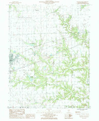
1985 Map of Altamont East
USGS Topo · Published 1986About this map
The town of Altamont serves as the focal point of this mid-1980s landscape, where the Conrail line cuts a straight path through the central prairies. The area is defined by a dense network of small drainages and township divisions including Moccasin, Summit, and Mound. Local infrastructure is notably captured through the Altamont Reservoir and the Old Altamont Reservoir, indicating the evolving water management needs of the community. Rural life is anchored by smaller named clusters like Dexter, Keptown, and Blue Point, while the terrain is etched by the meandering courses of Big Creek, Lily Creek, and Second Creek. These waterways eventually feed toward the L Wabash R in the southeast corner. Genealogists will find several small Cem notations scattered across the grid, marking the locations of quiet country burial grounds serving these longstanding Effingham County townships.
Find a feature on this map
21 named features on this map. Tap any name to fly to it.
Don’t see what you’re looking for? This feature index may not catch every label — zoom into the map to look around manually.
Map Details
Editions of this 1985 Altamont East Map
This is the sole edition of this map. No revisions or reprints were ever made.
Other maps of this area

1941 · St. Elmo
USGS Topo · 1:62,500

1945 · St. Elmo
USGS Topo · 1:62,500

1945 · Kinmundy
USGS Topo · 1:62,500

1947 · Kinmundy
USGS Topo · 1:62,500

1950 · Effingham
USGS Topo · 1:62,500

1951 · Effingham
USGS Topo · 1:62,500

1956 · Edgewood
USGS Topo · 1:62,500

1958 · Decatur
USGS Topo · 1:250,000

1958 · Belleville
USGS Topo · 1:250,000

1961 · Decatur
USGS Topo · 1:250,000