
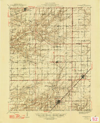
1947 Map of Kinmundy
USGS Topo · Published 1947About this map
Kinmundy and the surrounding prairie of Fayette Co Marion Co and Fayette Counties appear at the height of their post-war rural development. The landscape is defined by a dense grid of country schools like Shanghai Sch and Brush College Sch, serving the small agricultural hamlets that follow the railroads. The Illinois Central and Chicago and Eastern Illinois lines intersect at the southern edge, establishing the region as a vital transportation corridor for south-central Illinois.
Find a feature on this map
77 named features on this map. Tap any name to fly to it.
Don’t see what you’re looking for? This feature index may not catch every label — zoom into the map to look around manually.
Map Details
Editions of this 1947 Kinmundy Map
2 editions found
Other maps of this area

1914 · Centralia
USGS Topo · 1:62,500

1934 · Salem
USGS Topo · 1:62,500

1935 · Centralia
USGS Topo · 1:62,500

1938 · Salem
USGS Topo · 1:62,500

1941 · St. Elmo
USGS Topo · 1:62,500

1944 · Ramsey
USGS Topo · 1:62,500

1945 · St. Elmo
USGS Topo · 1:62,500

1945 · Kinmundy
USGS Topo · 1:62,500

1945 · Vandalia
USGS Topo · 1:62,500

1946 · Ramsey
USGS Topo · 1:62,500