
1950 Map of Alton
USGS Topo · Published 1959About this map
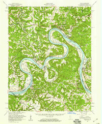
The Ohio River dominates this mid-century landscape, winding through a series of dramatic loops including Big Bend and Oxbow Bend. This survey illustrates the intricate relationship between the river and the settlements along the Indiana and Kentucky borders during the late 1940s and 1950. Along the northern bank, the town of Leavenworth and the smaller New Amsterdam serve as primary centers, while the interior is dotted with rural institutions like the St Theresa Academy and numerous country schools such as Beechland Sch and Mint Springs Sch.
Find a feature on this map
104 named features on this map. Tap any name to fly to it.
Don’t see what you’re looking for? This feature index may not catch every label — zoom into the map to look around manually.
Map Details
Editions of this 1950 Alton Map
2 editions found
Other maps of this area

1928 · Hardinsburg
USGS Topo · 1:48,000

1931 · Hardinsburg
USGS Topo · 1:62,500

1931 · Corydon
USGS Topo · 1:62,500

1934 · Cannelton
USGS Topo · 1:62,500

1941 · Ekron
USGS Topo · 1:62,500

1944 · Corydon West
USGS Topo · 1:24,000

1946 · Leavenworth
USGS Topo · 1:24,000

1946 · Depauw
USGS Topo · 1:24,000

1947 · Irvington
USGS Topo · 1:24,000

1947 · Lodiburg
USGS Topo · 1:24,000