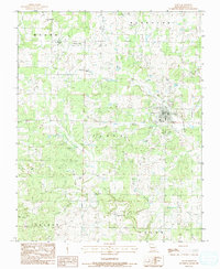
1983 Map of Alton
USGS Topo · Published 1984About this map
Alton serves as the focal point of this early 1980s survey, situated where the terrain transitions into the creek-carved hollows of southern Missouri. The community is anchored by local institutions like the High Sch and Victory Ch, while the surrounding landscape is defined by its water sources and family landmarks. The network of drainage includes Piney Creek, Frederick Creek, and the spring-fed Norman Branch, illustrating the rural reliance on these natural features.
Find a feature on this map
39 named features on this map. Tap any name to fly to it.
Don’t see what you’re looking for? This feature index may not catch every label — zoom into the map to look around manually.
Map Details
Editions of this 1983 Alton Map
This is the sole edition of this map. No revisions or reprints were ever made.
Other maps of this area

1931 · Bandyville
USGS Topo · 1:48,000

1943 · Thayer
USGS Topo · 1:62,500

1944 · Couch
USGS Topo · 1:62,500

1944 · Birch Tree
USGS Topo · 1:62,500

1945 · Montier
USGS Topo · 1:62,500

1946 · Thayer
USGS Topo · 1:62,500

1946 · Couch
USGS Topo · 1:62,500

1948 · Montier
USGS Topo · 1:62,500

1948 · Birch Tree
USGS Topo · 1:62,500

1957 · Poplar Bluff
USGS Topo · 1:250,000