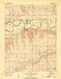
1953 Map of Alton
USGS Topo · Published 1954About this map
The South Fork Solomon River defines the central valley of this northern Kansas landscape, where the town of Alton serves as the primary hub along the Missouri Pacific railroad. To the south, the terrain rises into the uplands of the Sumner and Mount Ayr districts, revealing a rural social fabric built around small community centers. Genealogy researchers will find several well-documented landmarks of early settlement, including Mount Ayr Church, the nearby Mount Ayr School, and Kill Creek Church farther east.
Find a feature on this map
22 named features on this map. Tap any name to fly to it.
Don’t see what you’re looking for? This feature index may not catch every label — zoom into the map to look around manually.
Map Details
Editions of this 1953 Alton Map
3 editions found
Other maps of this area

1893 · Smith Center
USGS Topo · 1:125,000

1893 · Phillipsburg
USGS Topo · 1:125,000

1896 · Osborne
USGS Topo · 1:125,000

1896 · Plainville
USGS Topo · 1:125,000

1953 · Bloomington
USGS Topo · 1:24,000

1953 · Woodston
USGS Topo · 1:24,000

1953 · Alton
USGS Topo · 1:24,000

1955 · Beloit
USGS Topo · 1:250,000

1959 · Beloit
USGS Topo · 1:250,000

1961 · Kirwin SE
USGS Topo · 1:24,000