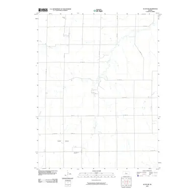
2009 Map of Alton SW
USGS Topo · Published 2009About this map
Mount Ayr and the prominent Round Mound anchor this section of north-central Kansas, where the landscape is defined by the drainages of Medicine Creek and Kill Creek. This 2009 survey reflects the enduring rural character of the region, marked by a precise grid of county roads such as S 260th Ave and W 160th Dr that facilitate access across the open terrain. Genealogists will find the Round Mound Cemetery situated along S 260th Ave, a quiet landmark serving as a vital record for the families who settled this high plains area. The map illustrates how local topography and watercourses dictated the placement of homesteads and infrastructure, far from any major urban centers.
Find a feature on this map
24 named features on this map. Tap any name to fly to it.
Don’t see what you’re looking for? This feature index may not catch every label — zoom into the map to look around manually.
Map Details
Editions of this 2009 Alton SW Map
This is the sole edition of this map. No revisions or reprints were ever made.
Other maps of this area

1896 · Osborne
USGS Topo · 1:125,000

1896 · Plainville
USGS Topo · 1:125,000

1953 · Bloomington
USGS Topo · 1:24,000

1953 · Woodston
USGS Topo · 1:24,000

1953 · Alton
USGS Topo · 1:24,000

1955 · Beloit
USGS Topo · 1:250,000

1959 · Beloit
USGS Topo · 1:250,000
1978 · Natoma
USGS Topo · 1:24,000
1978 · Paradise NW
USGS Topo · 1:24,000
1978 · Alton SW
USGS Topo · 1:24,000