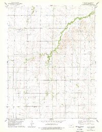
1978 Map of Alton SW
USGS Topo · Published 1979About this map
Round Mound and Mount Ayr define the high ground of this Osborne County landscape, where the drainage of Kill Creek and Medicine Creek carves a complex network of draws and ridges. During the late 1970s, this rural township was defined by its scattered communal landmarks and agricultural infrastructure. The presence of Round Mound Cem and Enterprise Ch suggests the enduring footprint of early settlers in the Victor area. This survey identifies highly localized details for genealogists and land researchers, such as the Kill Creek No 2 school site and the path of a significant Pipeline crossing the southern sections. The map serves as a record of the mid-century rural school system and the sparse, creek-dependent settlement pattern of the Kansas plains.
Find a feature on this map
9 named features on this map. Tap any name to fly to it.
Don’t see what you’re looking for? This feature index may not catch every label — zoom into the map to look around manually.
Map Details
Editions of this 1978 Alton SW Map
This is the sole edition of this map. No revisions or reprints were ever made.
Other maps of this area

1896 · Osborne
USGS Topo · 1:125,000

1896 · Plainville
USGS Topo · 1:125,000

1953 · Bloomington
USGS Topo · 1:24,000

1953 · Woodston
USGS Topo · 1:24,000

1953 · Alton
USGS Topo · 1:24,000

1955 · Beloit
USGS Topo · 1:250,000

1959 · Beloit
USGS Topo · 1:250,000
1978 · Natoma
USGS Topo · 1:24,000
1978 · Paradise NW
USGS Topo · 1:24,000
1978 · Covert
USGS Topo · 1:24,000