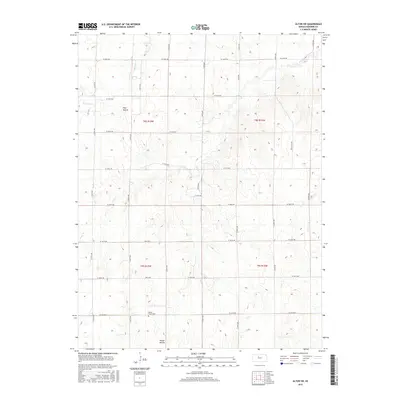
2015 Map of Alton SW
USGS Topo · Published 2015About this map
Round Mound and Pilot Mound rise as prominent topographic landmarks above the rural landscape of Osborne County. This high plains terrain is defined by a strictly surveyed section-line grid of rural routes such as S 270th Ave and W 200th Dr. Natural drainage follows the meandering courses of Medicine Cr and Kill Cr, which carve subtle valleys through the agricultural sections. For genealogists and local historians, the Round Mound Cem stands as a primary point of interest, located in the southern portion of the quadrangle near its namesake landform. The map provides a clear look at the late twentieth-century rural infrastructure, showing the transition between township boundaries like t8s r15w and t9s r15w in an area where the economy remains tied to the land and the drainage of the Solomon River watershed.
Find a feature on this map
28 named features on this map. Tap any name to fly to it.
Don’t see what you’re looking for? This feature index may not catch every label — zoom into the map to look around manually.
Map Details
Editions of this 2015 Alton SW Map
This is the sole edition of this map. No revisions or reprints were ever made.
Other maps of this area

1896 · Osborne
USGS Topo · 1:125,000

1896 · Plainville
USGS Topo · 1:125,000

1953 · Bloomington
USGS Topo · 1:24,000

1953 · Woodston
USGS Topo · 1:24,000

1953 · Alton
USGS Topo · 1:24,000

1955 · Beloit
USGS Topo · 1:250,000

1959 · Beloit
USGS Topo · 1:250,000
1978 · Natoma
USGS Topo · 1:24,000
1978 · Paradise NW
USGS Topo · 1:24,000
1978 · Alton SW
USGS Topo · 1:24,000