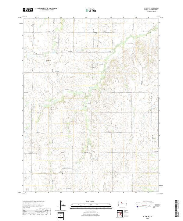
2022 Map of Alton SW
USGS Topo · Published 2022About this map
Round Mound Cem serves as a silent focal point in this portion of Osborne County, resting near the base of the prominent Round Mound elevation. This landscape is defined by the incision of Kill Cr and Medicine Cr through the high plains, creating a rugged topography that dictates the local road network. The gridded section lines are marked by a series of graded routes such as S 240th Ave and W 170th Dr, which circumvent geological features like Pilot Mound. The spatial arrangement of the cemetery and the surrounding mounds suggests a historical preference for utilizing these distinct high points as landmarks for the community's early burial grounds and navigation.
Find a feature on this map
28 named features on this map. Tap any name to fly to it.
Don’t see what you’re looking for? This feature index may not catch every label — zoom into the map to look around manually.
Map Details
Editions of this 2022 Alton SW Map
This is the sole edition of this map. No revisions or reprints were ever made.
Other maps of this area

1896 · Osborne
USGS Topo · 1:125,000

1896 · Plainville
USGS Topo · 1:125,000

1953 · Bloomington
USGS Topo · 1:24,000

1953 · Woodston
USGS Topo · 1:24,000

1953 · Alton
USGS Topo · 1:24,000

1955 · Beloit
USGS Topo · 1:250,000

1959 · Beloit
USGS Topo · 1:250,000
1978 · Natoma
USGS Topo · 1:24,000
1978 · Paradise NW
USGS Topo · 1:24,000
1978 · Alton SW
USGS Topo · 1:24,000