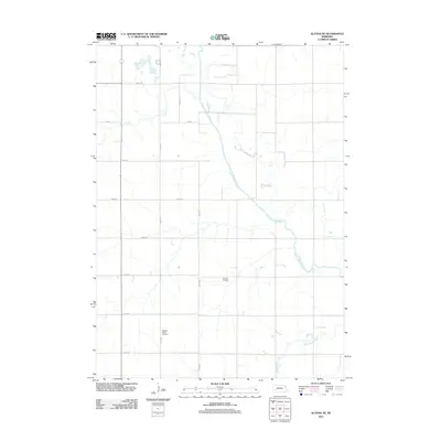
2011 Map of Altona NE
USGS Topo · Published 2011About this map
Pleasant Valley Cemetery stands as a quiet focal point in this portion of Thurston County, situated along a grid of rural roads like 585th Ave and 850th Rd. The landscape is defined by its water management and agricultural infrastructure, most notably the channelized path of the Logan Creek Dredge which cuts a straight line through the territory. Natural drainage persists through the winding courses of Coon Creek and Rattlesnake Creek, illustrating the intersection of natural hydrology and man-made modification. This 2011 survey also documents the local agricultural economy, specifically noting the location of Bruns Feedlot in the central part of the quadrangle. The map captures a meticulously organized section of the Nebraska prairie, where precise section lines and maintained thoroughfares dictate the flow of rural life and land use.
Find a feature on this map
16 named features on this map. Tap any name to fly to it.
Don’t see what you’re looking for? This feature index may not catch every label — zoom into the map to look around manually.
Map Details
Editions of this 2011 Altona NE Map
This is the sole edition of this map. No revisions or reprints were ever made.
Other maps of this area

1955 · Sioux City
USGS Topo · 1:250,000

1958 · Sioux City
USGS Topo · 1:250,000

1959 · Sioux City
USGS Topo · 1:250,000

1963 · Altona
USGS Topo · 1:24,000

1966 · Altona NW
USGS Topo · 1:24,000

1966 · Thurston
USGS Topo · 1:24,000
1966 · Altona SE
USGS Topo · 1:24,000

1966 · Altona NE
USGS Topo · 1:24,000
1966 · Pender
USGS Topo · 1:24,000

1967 · Wakefield SW
USGS Topo · 1:24,000