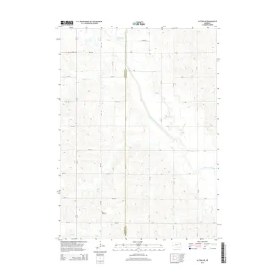
2014 Map of Altona NE
USGS Topo · Published 2014About this map
Wayne Co and Thurston Co meet along a straight north-south boundary line in this rural Nebraska landscape. The terrain is defined by the hydraulic history of its waterways, most notably the channelized Logan Creek Dredge, which runs alongside the meandering Old Channel Logan Creek. This juxtaposition illustrates decades of agricultural drainage efforts intended to manage the plains' watershed. Local history is anchored by the Pleasant Valley Cemetery in the southwest, while smaller tributaries like Coon Cr and Rattlesnake Cr feed the larger drainage system. The map reveals a strictly organized section-line road network, including routes like Mackee Ave and 850th Rd, which segment the rolling farmland and connect isolated farmsteads.
Find a feature on this map
24 named features on this map. Tap any name to fly to it.
Don’t see what you’re looking for? This feature index may not catch every label — zoom into the map to look around manually.
Map Details
Editions of this 2014 Altona NE Map
This is the sole edition of this map. No revisions or reprints were ever made.
Other maps of this area

1955 · Sioux City
USGS Topo · 1:250,000

1958 · Sioux City
USGS Topo · 1:250,000

1959 · Sioux City
USGS Topo · 1:250,000

1963 · Altona
USGS Topo · 1:24,000

1966 · Altona NW
USGS Topo · 1:24,000

1966 · Thurston
USGS Topo · 1:24,000
1966 · Altona SE
USGS Topo · 1:24,000

1966 · Altona NE
USGS Topo · 1:24,000
1966 · Pender
USGS Topo · 1:24,000

1967 · Wakefield SW
USGS Topo · 1:24,000