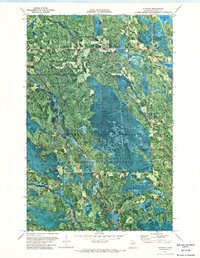
1971 Map of Alvwood
USGS Topo · Published 1974About this map
Alvwood and the surrounding Northwoods landscape of Itasca County are documented here through a specialized orthophotomap, which layers traditional topographic data over high-altitude aerial photography. This hybrid perspective reveals the dense timber and complex hydrology where the Chippewa National Forest and Blackduck State Forest meet. The settlement of Alvwood sits in the northeast, near a local Gravel Pit and the waters of Hamrey Lake.
Find a feature on this map
19 named features on this map. Tap any name to fly to it.
Don’t see what you’re looking for? This feature index may not catch every label — zoom into the map to look around manually.
Map Details
Editions of this 1971 Alvwood Map
This is the sole edition of this map. No revisions or reprints were ever made.
Other maps of this area

1919 · Rosy
USGS Topo · 1:62,500

1919 · Gemmell
USGS Topo · 1:62,500

1919 · Max
USGS Topo · 1:62,500

1919 · Bridgie
USGS Topo · 1:62,500

1924 · Bridgie
USGS Topo · 1:62,500

1954 · Bemidji
USGS Topo · 1:250,000

1957 · Bemidji
USGS Topo · 1:250,000

1958 · Bemidji
USGS Topo · 1:250,000

1971 · Squaw Lake
USGS Topo · 1:24,000

1971 · Dixon Lake
USGS Topo · 1:24,000