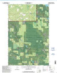
1996 Map of Alvwood
USGS Topo · Published 1998About this map
The Chippewa National Forest and Blackduck State Forest dominate this Itasca County landscape, where the administrative boundaries of national, state, and tribal lands overlap. Settlement centers on the small communities of Alvwood and Rosy, the latter of which includes the Rosy Cemetery. The terrain is defined by a dense network of wetlands and water bodies, including Upper Twin Lakes, Shallow Pond Lake, and the winding Popple River. A significant portion of the southeastern quadrant falls within the Leech Lake Indian Reservation, reflecting the complex jurisdictional history of this timber-rich region. Local infrastructure is primarily represented by a grid of Township Roads and small-scale excavations like the Gravel Pit, supporting a rural economy tied to the forest and its waterways.
Find a feature on this map
22 named features on this map. Tap any name to fly to it.
Don’t see what you’re looking for? This feature index may not catch every label — zoom into the map to look around manually.
Map Details
Editions of this 1996 Alvwood Map
This is the sole edition of this map. No revisions or reprints were ever made.
Other maps of this area

1919 · Rosy
USGS Topo · 1:62,500

1919 · Gemmell
USGS Topo · 1:62,500

1919 · Max
USGS Topo · 1:62,500

1919 · Bridgie
USGS Topo · 1:62,500

1924 · Bridgie
USGS Topo · 1:62,500

1954 · Bemidji
USGS Topo · 1:250,000

1957 · Bemidji
USGS Topo · 1:250,000

1958 · Bemidji
USGS Topo · 1:250,000

1971 · Squaw Lake
USGS Topo · 1:24,000

1971 · Dixon Lake
USGS Topo · 1:24,000