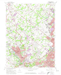
1966 Map of Ambler
USGS Topo · Published 1974About this map
Ambler and its surrounding Montgomery County landscape show a mid-century transition from agrarian roots to suburban density, punctuated by large institutional holdings and military installations. The U S Naval Air Station (Willow Grove) and Fort Washington State Park anchor the eastern and southern portions of the map, respectively. Educational growth is evident through the presence of Gwynedd-Mercy College and the Temple University (Ambler Campus), while older local history is preserved at the Graeme (Historical Site). The region's transport network is defined by the Reading and Penn Central railroads, which facilitated the growth of established communities like Spring House, Maple Glen, and Dresher. Substantial cemeteries and golf clubs, such as Whitemarsh Memorial Park (Cemetery) and Oak Terrace Country Club, occupy large tracts of land between the expanding residential subdivisions of Horsham and Warminster.
Find a feature on this map
190 named features on this map. Tap any name to fly to it.
Don’t see what you’re looking for? This feature index may not catch every label — zoom into the map to look around manually.
Map Details
Editions of this 1966 Ambler Map
4 editions found
Other maps of this area

1888 · Quakertown
USGS Topo · 1:62,500

1890 · Doylestown
USGS Topo · 1:62,500

1890 · Quakertown
USGS Topo · 1:62,500

1891 · Doylestown
USGS Topo · 1:62,500

1893 · Germantown
USGS Topo · 1:62,500

1894 · Quakertown
USGS Topo · 1:62,500

1894 · Norristown
USGS Topo · 1:62,500

1894 · Germantown
USGS Topo · 1:62,500

1895 · Norristown
USGS Topo · 1:62,500

1896 · Germantown
USGS Topo · 1:62,500
Featured Places
- Abington Township, PA
- Warminster Township, PA
- Horsham Township, PA
- Warrington Township, PA
- Whitemarsh Township, PA