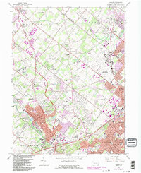
1966 Map of Ambler
USGS Topo · Published 1983About this map
Ambler and its surrounding townships in Montgomery and Bucks Counties reveal a landscape in the midst of post-war suburban transformation, where traditional estates and institutions met the rapid expansion of the Philadelphia periphery. This survey captures significant educational and cultural landmarks including Temple University (Ambler Campus), Gwynedd-Mercy College, and Germantown Academy, alongside the massive U S Naval Air Station (Willow Grove).
Find a feature on this map
104 named features on this map. Tap any name to fly to it.
Don’t see what you’re looking for? This feature index may not catch every label — zoom into the map to look around manually.
Map Details
Editions of this 1966 Ambler Map
4 editions found
Other maps of this area

1888 · Quakertown
USGS Topo · 1:62,500

1890 · Doylestown
USGS Topo · 1:62,500

1890 · Quakertown
USGS Topo · 1:62,500

1891 · Doylestown
USGS Topo · 1:62,500

1893 · Germantown
USGS Topo · 1:62,500

1894 · Quakertown
USGS Topo · 1:62,500

1894 · Norristown
USGS Topo · 1:62,500

1894 · Germantown
USGS Topo · 1:62,500

1895 · Norristown
USGS Topo · 1:62,500

1896 · Germantown
USGS Topo · 1:62,500
Featured Places
- Abington Township, PA
- Warminster Township, PA
- Horsham Township, PA
- Warrington Township, PA
- Whitemarsh Township, PA