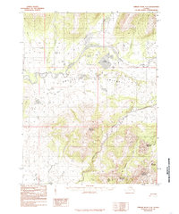
1985 Map of Ambler River A-3
USGS Topo · Published 1985About this map
The Ambler River cuts a wide path through this Arctic landscape, creating the expansive Ambler Lowland where surface water gathers into distinctive features like Lake Anirak and Lake Talhak. This 1985 survey, based on aerial photography from the mid-1970s, reveals a terrain defined by high peaks and an intricate drainage network. To the south and east, the elevation rises sharply into a series of named summits including Bismark Mountain, Eightmile Mountain, and the massive Shungnak Mountain. The hydrology is remarkably complex, with numerous tributaries such as Woodchopper Creek, Kalurivik Creek, and Cosmos Creek feeding the main river system. The proximity of Cosmos Mountain and Iron Mountain suggests a geologically significant area where the flat river basin meets the southern reaches of the Brooks Range foothills.
Find a feature on this map
21 named features on this map. Tap any name to fly to it.
Don’t see what you’re looking for? This feature index may not catch every label — zoom into the map to look around manually.
Map Details
Editions of this 1985 Ambler River A-3 Map
This is the sole edition of this map. No revisions or reprints were ever made.
Other maps of this area

1951 · Shungnak
USGS Topo · 1:250,000

1951 · Ambler River
USGS Topo · 1:250,000

1955 · Shungnak
USGS Topo · 1:250,000

1955 · Ambler River A-4
USGS Topo · 1:63,360

1955 · Shungnak D-4
USGS Topo · 1:63,360

1955 · Shungnak D-2
USGS Topo · 1:63,360

1955 · Shungnak D-3
USGS Topo · 1:63,360

1956 · Ambler River
USGS Topo · 1:250,000

1964 · Shungnak
USGS Topo · 1:250,000

1964 · Ambler River
USGS Topo · 1:250,000