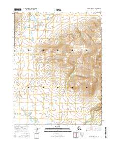
2016 Map of Ambler River A-3 SW
USGS Topo · Published 2016About this map
Ingricherk Mtn and Bismark Mtn anchor this sub-arctic landscape in the northern interior, where the high ridges of the Northwest Arctic Borough meet the headwaters of the Kobuk River drainage. This 2016 survey illustrates a largely untouched wilderness defined by its seasonal hydrology, where Woodchopper Cr and Garland Cr wind through the valley floor. The eastern edge of the quadrangle is defined by the Shungnak River, a significant waterway that has historically provided a corridor for travel and subsistence in this part of the Ambler River region. The map provides a precise layout of the Public Land Survey System boundaries, including t20n r7e and t19n r7e, which are essential for understanding land ownership and mineral claims in this resource-rich but sparsely populated territory.
Find a feature on this map
9 named features on this map. Tap any name to fly to it.
Don’t see what you’re looking for? This feature index may not catch every label — zoom into the map to look around manually.
Map Details
Editions of this 2016 Ambler River A-3 SW Map
This is the sole edition of this map. No revisions or reprints were ever made.
Other maps of this area

1951 · Shungnak
USGS Topo · 1:250,000

1951 · Ambler River
USGS Topo · 1:250,000

1955 · Shungnak
USGS Topo · 1:250,000

1955 · Ambler River A-4
USGS Topo · 1:63,360

1955 · Shungnak D-4
USGS Topo · 1:63,360

1955 · Shungnak D-3
USGS Topo · 1:63,360

1956 · Ambler River
USGS Topo · 1:250,000

1964 · Shungnak
USGS Topo · 1:250,000

1964 · Ambler River
USGS Topo · 1:250,000
1966 · Ambler River A-4
USGS Topo · 1:63,360