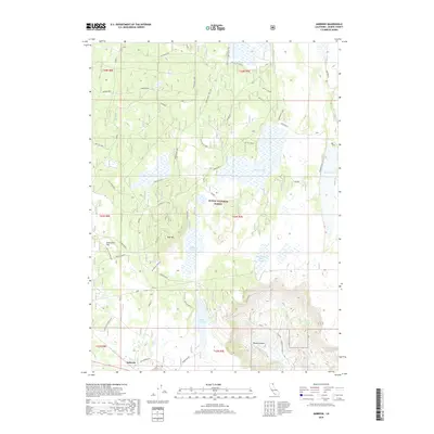
2018 Map of Ambrose
USGS Topo · Published 2018About this map
Ambrose serves as a lone focal point in this high-desert landscape of Modoc County, surrounded by the protected expanses of the Modoc National Forest. The map documents a rugged terrain shaped by volcanic and tectonic history, evidenced by features like Rail Mtn and the deep cut of Blacks Canyon. Water management is central to the land's utility in this arid region, as seen in the distribution of infrastructure like Duncan Reservoir, Williams Reservoir, and the Six-Shooter Stock Tank. The extensive network of forest roads and trails, such as Tichnor Road and Old Loveness Rd, reveals a landscape managed for timber, grazing, and seasonal access. Distinctive natural landmarks like Sevenmile Flat and Gas Drum Flat contrast with the wetland pockets of Bucher Swamp, illustrating the ecological variety of the California interior.
Find a feature on this map
41 named features on this map. Tap any name to fly to it.
Don’t see what you’re looking for? This feature index may not catch every label — zoom into the map to look around manually.
Map Details
Editions of this 2018 Ambrose Map
This is the sole edition of this map. No revisions or reprints were ever made.
Other maps of this area

1886 · Alturas
USGS Topo · 1:250,000

1886 · Modoc Lava Bed
USGS Topo · 1:250,000

1892 · Modoc Lava-Bed
USGS Topo · 1:250,000

1892 · Alturas
USGS Topo · 1:250,000

1952 · Hackamore
USGS Topo · 1:62,500

1954 · Alturas
USGS Topo · 1:250,000

1958 · Alturas
USGS Topo · 1:250,000

1961 · Canby
USGS Topo · 1:62,500

1962 · Alturas
USGS Topo · 1:250,000

1962 · Crank Mountain
USGS Topo · 1:62,500