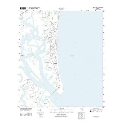
2012 Map of Amelia City
USGS Topo · Published 2012About this map
Amelia Island dominates this coastal landscape, showing the 2012 footprint of several distinct communities including Amelia City, American Beach, and Franklintown. The map illustrates a complex network of barrier islands and waterways where the S Amelia River and Nassau River converge toward the Nassau Sound. In the south, the settlement of Black Hammock is visible near the marshes of Talbot Island, providing a detailed look at the interface between established residential developments and the sprawling tidal creek systems like Sawpit Cr and Walker Cr. The interior of the island shows a dense grid of local roads and planned developments, such as Philips Manor Rd and Amelia Island Pkwy, which contrast with the open grounds of the Fernandina Beach Municipal Airport and the expansive shoreline along the Atlantic Ocean.
Find a feature on this map
75 named features on this map. Tap any name to fly to it.
Don’t see what you’re looking for? This feature index may not catch every label — zoom into the map to look around manually.
Map Details
Editions of this 2012 Amelia City Map
This is the sole edition of this map. No revisions or reprints were ever made.
Other maps of this area

1918 · St Marys
USGS Topo · 1:62,500

1918 · Jacksonville
USGS Topo · 1:62,500

1918 · Mayport
USGS Topo · 1:62,500

1919 · Fernandina
USGS Topo · 1:62,500

1919 · St Marys
USGS Topo · 1:62,500

1944 · Fernandina
USGS Topo · 1:62,500

1948 · Jacksonville
USGS Topo · 1:250,000

1948 · Eastport
USGS Topo · 1:24,000
1950 · Mayport
USGS Topo · 1:24,000
1950 · Eastport
USGS Topo · 1:24,000