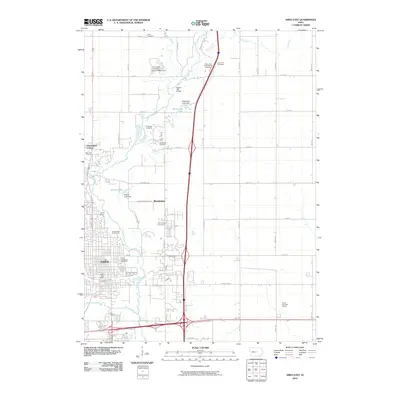
2010 Map of Ames East
USGS Topo · Published 2010About this map
The South Skunk River and Squaw Creek define the eastern expansion of Ames as it appeared in the early 21st century. This survey documents the transition from the city’s urban core, anchored by the Ames Post Office, to the surrounding agricultural landscape where the Iowa State University Experimental Farm operates. Settlement patterns are evidenced by the clusters of family and municipal burial grounds such as Bloomington Cemetery, Arrasmith Cemetery, and the Ames Municipal Cemetery. Infrastructure is a primary focus, showcasing the modern highway interchanges crossing the historic Lincoln Hwy corridor. Smaller settlements like Bloomington and Homestead Colony sit along the western margins, while landmarks such as Sopers Mill Bridge and Arnold Lake provide focal points along the river valley. The map offers a precise view of the local road grid, from major thoroughfares like Dayton Ave to rural routes including Arrasmith Trl and Stagecoach Rd.
Find a feature on this map
54 named features on this map. Tap any name to fly to it.
Don’t see what you’re looking for? This feature index may not catch every label — zoom into the map to look around manually.
Map Details
Editions of this 2010 Ames East Map
This is the sole edition of this map. No revisions or reprints were ever made.
Other maps of this area

1911 · Slater
USGS Topo · 1:62,500

1912 · Ames
USGS Topo · 1:62,500

1913 · Slater
USGS Topo · 1:62,500

1914 · Ames
USGS Topo · 1:62,500

1954 · Waterloo
USGS Topo · 1:250,000

1954 · Des Moines
USGS Topo · 1:250,000

1955 · Waterloo
USGS Topo · 1:250,000

1956 · Des Moines
USGS Topo · 1:250,000

1957 · Des Moines
USGS Topo · 1:250,000

1969 · Des Moines
USGS Topo · 1:250,000