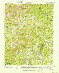
1952 Map of Amherst
USGS Topo · Published 1952About this map
The George Washington National Forest and the peaks of the Blue Ridge dominate this mid-century portrait of Central Virginia. The rugged topography is traversed by the Appalachian Trail and the scenic Blue Ridge Parkway, which follow the high ridges past landmarks like Bald Knob and High Peak. In the valleys, the landscape is defined by the Buffalo River and Piney River drainage systems, where small crossroads communities and rural institutions flourished. Local commerce and education are represented by family-named landmarks such as Henleys Store, Crawfords Store, and numerous schools like Temperance Sch and Chestnut Grove Sch. Near the county seat of Amherst, the Sweet Briar College campus stands as a major cultural anchor, while the Southern railroad line connects the southern settlements of Monroe and Faulconerville to the broader regional economy.
Find a feature on this map
95 named features on this map. Tap any name to fly to it.
Don’t see what you’re looking for? This feature index may not catch every label — zoom into the map to look around manually.
Map Details
Editions of this 1952 Amherst Map
This is the sole edition of this map. No revisions or reprints were ever made.
Other maps of this area

1892 · Lynchburg
USGS Topo · 1:125,000

1892 · Buckingham
USGS Topo · 1:125,000

1892 · Appomattox
USGS Topo · 1:125,000

1894 · Lexington
USGS Topo · 1:125,000

1932 · Lexington
USGS Topo · 1:48,000

1935 · Buena Vista
USGS Topo · 1:48,000

1935 · Amherst
USGS Topo · 1:48,000

1936 · Vesuvius
USGS Topo · 1:48,000

1937 · Lexington
USGS Topo · 1:62,500

1939 · Amherst
USGS Topo · 1:62,500