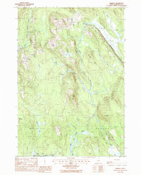
1988 Map of Amherst
USGS Topo · Published 1988About this map
The West Branch Union River, Middle Branch Union River, and East Branch Union River converge in this corner of Hancock County, defining a landscape of glacial ridges and complex drainage systems. The small settlements of Amherst and Aurora are positioned along the high ground, while the southern reaches near Waltham and North Mariaville follow the river corridors. Of particular interest is the prominent esker known as The Whalesback, a classic post-glacial formation that dictates the path of local travel and drainage. The interior is marked by significant elevations like Silsby Hill and Moose Hill, interspersed with isolated water bodies such as Giles Pond. This map documents a period when the local economy remained tied to the timber and river network, with numerous brooks like Archer Brook and Joe Moore Brook feeding into the primary branches of the Union River.
Find a feature on this map
36 named features on this map. Tap any name to fly to it.
Don’t see what you’re looking for? This feature index may not catch every label — zoom into the map to look around manually.
Map Details
Editions of this 1988 Amherst Map
This is the sole edition of this map. No revisions or reprints were ever made.
Other maps of this area

1911 · Ellsworth
USGS Topo · 1:62,500

1929 · Great Pond
USGS Topo · 1:48,000

1929 · Lead Mountain
USGS Topo · 1:48,000

1930 · Tunk Lake
USGS Topo · 1:48,000

1932 · Tunk Lake
USGS Topo · 1:62,500

1932 · Lead Mountain
USGS Topo · 1:62,500

1932 · Great Pond
USGS Topo · 1:62,500

1940 · Ellsworth
USGS Topo · 1:62,500

1942 · Ellsworth
USGS Topo · 1:62,500

1942 · Tunk Lake
USGS Topo · 1:62,500