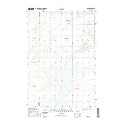
2015 Map of Amherst
USGS Topo · Published 2015About this map
The Newport Colony and the town of Amherst define the landscape of this northeastern South Dakota survey. Situated along the Brown County and Marshall County line, the area displays a distinct grid-based agricultural organization typical of the James River Valley. Local genealogy and community history are anchored by the Amherst Cem to the north and the Free Mission Cem further south. The settlement of Amherst is notable for its diagonal street layout, including Front St and Center St, which cuts across the standard cardinal grid of rural roads like 114th St and 414th Ave. This geometric contrast highlights the historical influence of rail-oriented town planning amidst the vast Section-Township-Range divisions of the surrounding prairie.
Find a feature on this map
26 named features on this map. Tap any name to fly to it.
Don’t see what you’re looking for? This feature index may not catch every label — zoom into the map to look around manually.
Map Details
Editions of this 2015 Amherst Map
This is the sole edition of this map. No revisions or reprints were ever made.
Other maps of this area

1894 · Hecla
USGS Topo · 1:62,500

1896 · Columbia
USGS Topo · 1:125,000

1952 · Huffton
USGS Topo · 1:24,000

1953 · Hecla SE
USGS Topo · 1:24,000

1953 · Newark SW
USGS Topo · 1:24,000

1953 · Milbank
USGS Topo · 1:250,000

1954 · Aberdeen
USGS Topo · 1:250,000

1956 · Aberdeen
USGS Topo · 1:250,000

1956 · Britton West
USGS Topo · 1:24,000
1956 · Claremont
USGS Topo · 1:24,000
Featured Places
- Newport Hutterite Colony, SD
- Amherst, SD
- South Detroit Township, SD
- Claremont Township, SD
- Brown County, SD