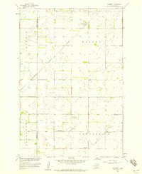
1958 Map of Amherst
USGS Topo · Published 1959About this map
Amherst serves as the focal point of this late 1950s prairie landscape, situated along the Great Northern railroad line at the junction of Weston and Detroit townships. The map documents a period when rural education and community life remained anchored by localized landmarks, including several one-room schoolhouses such as School No 3, School No 4, and School No 6. The geography is defined by a series of depressions and small water bodies, notable for the presence of multiple Flowing Wells which indicate the importance of artesian water sources for agriculture in this portion of Marshall County and Brown County. Local genealogy and burial history are anchored by the Amherst Cem and the Free Mission Cem, providing precise locations for researchers tracing the early families of Newport and the surrounding townships.
Find a feature on this map
13 named features on this map. Tap any name to fly to it.
Don’t see what you’re looking for? This feature index may not catch every label — zoom into the map to look around manually.
Map Details
Editions of this 1958 Amherst Map
This is the sole edition of this map. No revisions or reprints were ever made.
Other maps of this area

1894 · Hecla
USGS Topo · 1:62,500

1896 · Columbia
USGS Topo · 1:125,000

1952 · Huffton
USGS Topo · 1:24,000

1953 · Hecla SE
USGS Topo · 1:24,000

1953 · Newark SW
USGS Topo · 1:24,000

1953 · Milbank
USGS Topo · 1:250,000

1954 · Aberdeen
USGS Topo · 1:250,000

1956 · Aberdeen
USGS Topo · 1:250,000

1956 · Britton West
USGS Topo · 1:24,000
1956 · Claremont
USGS Topo · 1:24,000
Featured Places
- Newport Hutterite Colony, SD
- Amherst, SD
- South Detroit Township, SD
- Claremont Township, SD
- Brown County, SD