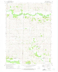
1973 Map of Amish
USGS Topo · Published 1975About this map
The settlement of Amish and the nearby Mennonite Sch anchor the southeastern corner of this Iowa landscape, where local life follows the drainages of Old Mans Creek and the English River. Mapped in the early 1970s, the terrain reveals a dense network of rural community centers, particularly noted by the clustering of denominational landmarks like Upper Deer Creek Ch and Lower Deer Creek Ch. The township lines of York, Hardin, Greene, and Washington intersect here, defining the borders of Iowa, Johnson, and Washington counties.
Find a feature on this map
31 named features on this map. Tap any name to fly to it.
Don’t see what you’re looking for? This feature index may not catch every label — zoom into the map to look around manually.
Map Details
Editions of this 1973 Amish Map
This is the sole edition of this map. No revisions or reprints were ever made.
Other maps of this area

1891 · Oxford
USGS Topo · 1:62,500

1891 · Iowa City
USGS Topo · 1:62,500

1894 · Oxford
USGS Topo · 1:62,500

1903 · Fairfax
USGS Topo · 1:125,000

1938 · Iowa City
USGS Topo · 1:62,500

1958 · Davenport
USGS Topo · 1:250,000

1961 · Davenport
USGS Topo · 1:250,000

1962 · Davenport
USGS Topo · 1:250,000

1965 · Williamstown
USGS Topo · 1:24,000
1965 · Tiffin
USGS Topo · 1:24,000