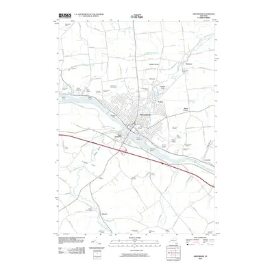
2010 Map of Amsterdam
USGS Topo · Published 2010About this map
The Mohawk River and the historic Erie Canal corridor define this region of Montgomery County, where the industrial city of Amsterdam serves as a central hub. The landscape is marked by a high density of religious and community burial grounds, including the extensive Green Hill Cemetery and Saint Josephs Cemetery, reflecting the area's diverse immigrant heritage and long-settled river towns. North of the river, smaller settlements like Hagaman, Rockton, and Manny Corners are connected by a network of creeks such as North Chuctanunda Creek and McQueen Creek. South of the river, the terrain rises into the Florida Hills near Minaville, where the Florida Town Bridge crosses South Chuctanunda Creek. This 2010 survey illustrates the persistent importance of the river valley for modern transportation via I-90 and NY 5, while maintaining the distinct boundaries of historical hamlets like Fort Johnson and Cranesville.
Find a feature on this map
116 named features on this map. Tap any name to fly to it.
Don’t see what you’re looking for? This feature index may not catch every label — zoom into the map to look around manually.
Map Details
Editions of this 2010 Amsterdam Map
This is the sole edition of this map. No revisions or reprints were ever made.
Other maps of this area

1895 · Amsterdam
USGS Topo · 1:62,500

1896 · Fonda
USGS Topo · 1:62,500

1898 · Fonda
USGS Topo · 1:62,500

1899 · Broadalbin
USGS Topo · 1:62,500

1902 · Broadalbin
USGS Topo · 1:62,500

1902 · Fonda
USGS Topo · 1:62,500

1903 · Gloversville
USGS Topo · 1:62,500

1931 · Amsterdam
USGS Topo · 1:62,500

1943 · Gloversville
USGS Topo · 1:62,500
1943 · Esperance
USGS Topo · 1:24,000