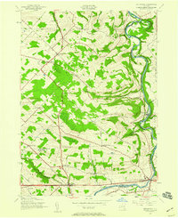
1943 Map of Esperance
USGS Topo · Published 1959About this map
Schoharie Creek carves a deep path through this landscape, winding past the notable bends of Lost Valley and the settlement of Esperance. During this mid-century period, the area remained deeply rural, defined by a network of numbered school districts and scattered hamlets like Charleston and Sloansville. The map captures a transition in transportation, showing both the local farm-to-market crossroads such as Market Corners and Davis Corners alongside more modern arterial developments like the 4 Lane and 2 Lane roads near the Schoharie County line. Genealogists and local historians can find a wealth of specific landmarks, including the Kimball Cem and numerous rural schoolhouses such as the Burtonsville Sch, Carytown Sch, and Mountange Sch, which served the outlying agricultural communities of Glen and Duanesburg.
Find a feature on this map
39 named features on this map. Tap any name to fly to it.
Don’t see what you’re looking for? This feature index may not catch every label — zoom into the map to look around manually.
Map Details
Editions of this 1943 Esperance Map
2 editions found
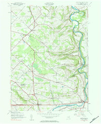
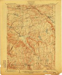
Other maps of this area

1895 · Amsterdam
USGS Topo · 1:62,500

1896 · Fonda
USGS Topo · 1:62,500

1898 · Fonda
USGS Topo · 1:62,500

1898 · Schoharie
USGS Topo · 1:62,500

1900 · Schoharie
USGS Topo · 1:62,500

1900 · Schoharie
USGS Topo · 1:31,680

1900 · Berne
USGS Topo · 1:62,500

1902 · Fonda
USGS Topo · 1:62,500
1903 · Berne
USGS Topo · 1:62,500

1931 · Amsterdam
USGS Topo · 1:62,500