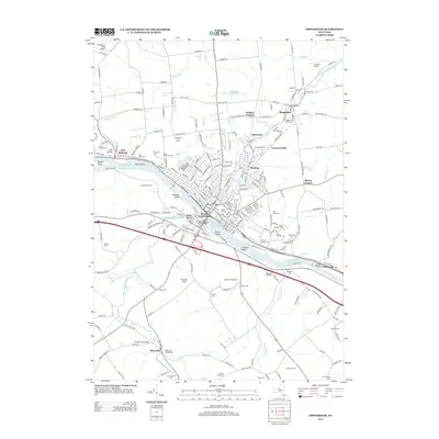
2013 Map of Amsterdam
USGS Topo · Published 2013About this map
The Mohawk River serves as the central artery of this region, separating the industrial and residential core of South Amsterdam from the expansive parklands and residential neighborhoods to the north. This 2013 survey reveals a landscape deeply marked by its cemeteries, reflecting the generational history of the communities here, from Saint Marys Cem and Fairview Cem in the west to the dense cluster including Saint Johns Cem and Saint Michael Cem near Crescent Park. The infrastructure of the era is evident in the Chuctanunda Creek Bridge and the Mohawk Rest Area, which facilitate travel along the valley's established transport corridors.
Find a feature on this map
230 named features on this map. Tap any name to fly to it.
Don’t see what you’re looking for? This feature index may not catch every label — zoom into the map to look around manually.
Map Details
Editions of this 2013 Amsterdam Map
This is the sole edition of this map. No revisions or reprints were ever made.
Other maps of this area

1895 · Amsterdam
USGS Topo · 1:62,500

1896 · Fonda
USGS Topo · 1:62,500

1898 · Fonda
USGS Topo · 1:62,500

1899 · Broadalbin
USGS Topo · 1:62,500

1902 · Broadalbin
USGS Topo · 1:62,500

1902 · Fonda
USGS Topo · 1:62,500

1903 · Gloversville
USGS Topo · 1:62,500

1931 · Amsterdam
USGS Topo · 1:62,500

1943 · Gloversville
USGS Topo · 1:62,500
1943 · Esperance
USGS Topo · 1:24,000