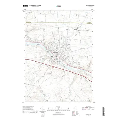
2019 Map of Amsterdam
USGS Topo · Published 2019About this map
Amsterdam serves as the focal point of this industrial and riverine landscape, where the Mohawk River carves through the terrain between Fulton and Montgomery counties. The city's geography is defined by its relationship with the water, featuring several river islands such as Bronson Island and Davey Island, and the critical North Chuctanunda Creek Bridge. The map reveals a dense network of suburban and rural settlements including Rockton, Hagaman, and Fort Johnson, each anchored by historical infrastructure like the Kellogg Reservoir. For genealogists, the area is notably rich in burial sites, with a high concentration of denominational grounds such as Saint Stanislaus Cem and Mount Carmel Cem reflecting the diverse cultural heritage of the Mohawk Valley's manufacturing era. To the south, the landscape transitions into the Florida Hills near Minaville, where the Florida Reformed Church stands as a landmark of earlier agricultural settlement patterns.
Find a feature on this map
164 named features on this map. Tap any name to fly to it.
Don’t see what you’re looking for? This feature index may not catch every label — zoom into the map to look around manually.
Map Details
Editions of this 2019 Amsterdam Map
This is the sole edition of this map. No revisions or reprints were ever made.
Other maps of this area

1895 · Amsterdam
USGS Topo · 1:62,500

1896 · Fonda
USGS Topo · 1:62,500

1898 · Fonda
USGS Topo · 1:62,500

1899 · Broadalbin
USGS Topo · 1:62,500

1902 · Broadalbin
USGS Topo · 1:62,500

1902 · Fonda
USGS Topo · 1:62,500

1903 · Gloversville
USGS Topo · 1:62,500

1931 · Amsterdam
USGS Topo · 1:62,500

1943 · Gloversville
USGS Topo · 1:62,500
1943 · Esperance
USGS Topo · 1:24,000