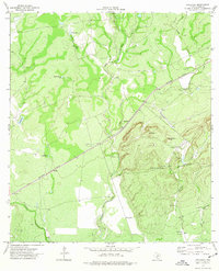
1974 Map of Anacacho
USGS Topo · Published 1977About this map
Anacacho Mountains dominate the eastern landscape of this Kinney County quadrangle, rising above the surrounding scrub and ranch lands. The Southern Pacific railroad cuts a straight diagonal through the center of the sheet, anchoring the small settlement at Anacacho. This area is characterized by an arid cattle-ranching economy, where survival depends on named water sources and infrastructure like Medina Tank, Double Header Tank, and Chacon Windmill.
Find a feature on this map
25 named features on this map. Tap any name to fly to it.
Don’t see what you’re looking for? This feature index may not catch every label — zoom into the map to look around manually.
Map Details
Editions of this 1974 Anacacho Map
This is the sole edition of this map. No revisions or reprints were ever made.
Other maps of this area

1896 · Brackett
USGS Topo · 1:125,000

1897 · Brackett
USGS Topo · 1:125,000

1938 · Turkey Mountain
USGS Topo · 1:48,000

1943 · Turkey Mountain
USGS Topo · 1:62,500

1944 · Spofford
USGS Topo · 1:62,500

1944 · Brackettville
USGS Topo · 1:62,500

1949 · Cline
USGS Topo · 1:62,500

1958 · Del Rio
USGS Topo · 1:250,000

1964 · Del Rio
USGS Topo · 1:250,000
1974 · Elm Mountain
USGS Topo · 1:24,000