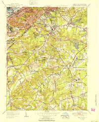
1951 Map of Anacostia
USGS Topo · Published 1951About this map
St Elizabeths Hospital and the Naval Receiving Sta dominate the western edge of this mid-century survey, marking the transition between the urbanized Anacostia district and the rapidly developing hills of Prince Georges Co. This era shows the federal footprint expanding significantly into the Maryland suburbs, evidenced by the Bureau of the Census in Suitland and the massive sprawl of Andrews Air Force Base to the east.
Find a feature on this map
110 named features on this map. Tap any name to fly to it.
Don’t see what you’re looking for? This feature index may not catch every label — zoom into the map to look around manually.
Map Details
Editions of this 1951 Anacostia Map
This is the sole edition of this map. No revisions or reprints were ever made.
Other maps of this area

1890 · Mt. Vernon
USGS Topo · 1:125,000

1891 · Mt. Vernon
USGS Topo · 1:125,000

1892 · Brandywine
USGS Topo · 1:62,500

1894 · Mt. Vernon
USGS Topo · 1:125,000

1895 · Brandywine
USGS Topo · 1:62,500

1897 · Mt. Vernon
USGS Topo · 1:125,000

1899 · Patuxent
USGS Topo · 1:125,000

1900 · Washington
USGS Topo · 1:62,500

1906 · Patuxent
USGS Topo · 1:125,000

1911 · Brandywine
USGS Topo · 1:62,500