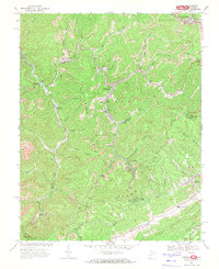
1968 Map of Anawalt
USGS Topo · Published 1972About this map
Anawalt sits at the center of this industrial landscape, where the coal-driven economy of the late 1960s is etched into the terrain of the Adkin District. The area is defined by the extensive operations of the Norfolk and Western railway, which snakes through the valleys to serve numerous extraction sites. Evidence of the region's intensive mining history is visible through numerous Strip Mines, Tailings Ponds, and a prominent Tipple near Anawalt.
Find a feature on this map
52 named features on this map. Tap any name to fly to it.
Don’t see what you’re looking for? This feature index may not catch every label — zoom into the map to look around manually.
Map Details
Editions of this 1968 Anawalt Map
2 editions found
Other maps of this area

1887 · Pocahontas
USGS Topo · 1:125,000

1891 · Tazewell
USGS Topo · 1:125,000

1891 · Pocahontas
USGS Topo · 1:125,000

1894 · Pocahontas
USGS Topo · 1:125,000

1895 · Tazewell
USGS Topo · 1:125,000

1895 · Pocahontas
USGS Topo · 1:125,000

1897 · Tazewell
USGS Topo · 1:125,000

1909 · Pocahontas Special
USGS Topo · 1:48,000

1911 · Pocahontas Special
USGS Topo · 1:62,500

1912 · Pounding Mill
USGS Topo · 1:62,500