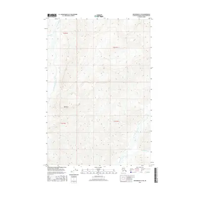
2016 Map of Anchorage D-4 NE
USGS Topo · Published 2016About this map
The Talkeetna Mountains dominate this high-elevation landscape, where deep drainages and steep ridges define the regional topography. The Chickaloon River flows through the western edge of the area, joined by the headwaters of Moss Creek. This 2016 survey illustrates the complex natural hydrology of the Matanuska-Susitna Borough, showing how smaller tributaries like Boulder Creek and East Boulder Creek carve through the mountain system. The map serves as a primary record of the untouched terrain within the Public Land Survey System grids of t22n r6e and t21n r7e, highlighting a region shaped by high-relief landforms rather than human infrastructure or settlement.
Find a feature on this map
9 named features on this map. Tap any name to fly to it.
Don’t see what you’re looking for? This feature index may not catch every label — zoom into the map to look around manually.
Map Details
Editions of this 2016 Anchorage D-4 NE Map
This is the sole edition of this map. No revisions or reprints were ever made.
Other maps of this area

1948 · Anchorage D-3
USGS Topo · 1:63,360

1948 · Anchorage D-4
USGS Topo · 1:63,360

1950 · Talkeetna Mountains
USGS Topo · 1:250,000

1951 · Anchorage
USGS Topo · 1:250,000

1951 · Talkeetna Mountains A-3
USGS Topo · 1:63,360

1952 · Anchorage D-4
USGS Topo · 1:63,360

1952 · Anchorage D-3
USGS Topo · 1:63,360
1952 · Talkeetna Mountains A-3
USGS Topo · 1:63,360

1954 · Talkeetna Mountains
USGS Topo · 1:250,000
1957 · Talkeetna Mountains
USGS Topo · 1:250,000