
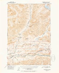
1952 Map of Anchorage D-4
USGS Topo · Published 1952About this map
Chickaloon serves as the primary hub of activity in this northern wilderness, situated where the Matanuska River meets its tributaries. The landscape is defined by the steep elevation changes between the Talkeetna Mountains and the Chugach Mountains, with the Glenn Highway providing the critical terrestrial link through the valley floor. Evidence of early industry and infrastructure is visible at the Coal Mine (Aban'd) and a nearby Cable Tramway, indicating the area's resource-driven history before mid-century.
Find a feature on this map
43 named features on this map. Tap any name to fly to it.
Don’t see what you’re looking for? This feature index may not catch every label — zoom into the map to look around manually.
Map Details
Editions of this 1952 Anchorage D-4 Map
2 editions found
Other maps of this area

1948 · Anchorage D-3
USGS Topo · 1:63,360

1948 · Anchorage D-4
USGS Topo · 1:63,360

1949 · Anchorage D-5
USGS Topo · 1:63,360

1949 · Talkeetna Mountains A-4
USGS Topo · 1:63,360

1950 · Talkeetna Mountains
USGS Topo · 1:250,000

1951 · Anchorage
USGS Topo · 1:250,000

1951 · Anchorage C-5
USGS Topo · 1:63,360

1951 · Talkeetna Mountains A-3
USGS Topo · 1:63,360

1952 · Anchorage D-5
USGS Topo · 1:63,360

1952 · Anchorage D-3
USGS Topo · 1:63,360