
1952 Map of Anchorage D-5
USGS Topo · Published 1952About this map
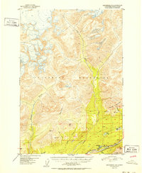
The Matanuska River and Kings River define the lower elevations of this 1952 topographic study, where the Glenn Highway provides the primary corridor for movement through the foothills of the Talkeetna Mountains. Settlement patterns are sparse, represented by small clusters of Cabins and the named locality of Castle situated near the base of Castle Mountain. The landscape reveals early industrial footprints, including an Oil Well and a Gravel Pit located east of Drill Lake.
Find a feature on this map
29 named features on this map. Tap any name to fly to it.
Don’t see what you’re looking for? This feature index may not catch every label — zoom into the map to look around manually.
Map Details
Editions of this 1952 Anchorage D-5 Map
2 editions found
Other maps of this area

1948 · Anchorage D-4
USGS Topo · 1:63,360

1949 · Anchorage D-5
USGS Topo · 1:63,360

1949 · Talkeetna Mountains A-4
USGS Topo · 1:63,360

1950 · Talkeetna Mountains
USGS Topo · 1:250,000

1950 · Anchorage D-6
USGS Topo · 1:63,360

1951 · Anchorage
USGS Topo · 1:250,000

1951 · Anchorage C-6
USGS Topo · 1:63,360

1951 · Anchorage C-5
USGS Topo · 1:63,360

1951 · Talkeetna Mountains A-3
USGS Topo · 1:63,360

1952 · Anchorage D-6
USGS Topo · 1:63,360