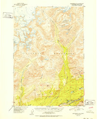
1952 Map of Anchorage D-5
USGS Topo · Published 1952About this map
The Talkeetna Mountains dominate the northern landscape of this 1952 topographic survey, where steep terrain drops toward the glacial valley of the Matanuska River. Along the southern corridor, the Glenn Highway provides the primary artery for transportation, winding past Castle Park and Thirtymile Lake. Early industrial activity in the region is evidenced by an Oil Well located near Drill Lake, while clusters of Cabins near Fish Lake suggest seasonal or remote habitation. The map highlights a complex drainage network where the Kings River and Granite Creek carve deep through the mountain blocks. Survey markers like VABM Castle 2914 and VABM King 3155 pinpoint prominent summits, including Castle Mountain and Kings Mtn, reflecting the detailed work of the U.S. Geological Survey and USC&GS in documenting this Alaskan interior before extensive modern development.
Find a feature on this map
28 named features on this map. Tap any name to fly to it.
Don’t see what you’re looking for? This feature index may not catch every label — zoom into the map to look around manually.
Map Details
Editions of this 1952 Anchorage D-5 Map
2 editions found

Other maps of this area

1948 · Anchorage D-4
USGS Topo · 1:63,360

1949 · Anchorage D-5
USGS Topo · 1:63,360

1949 · Talkeetna Mountains A-4
USGS Topo · 1:63,360

1950 · Talkeetna Mountains
USGS Topo · 1:250,000

1950 · Anchorage D-6
USGS Topo · 1:63,360

1951 · Anchorage
USGS Topo · 1:250,000

1951 · Anchorage C-6
USGS Topo · 1:63,360

1951 · Anchorage C-5
USGS Topo · 1:63,360

1951 · Talkeetna Mountains A-3
USGS Topo · 1:63,360

1952 · Anchorage D-6
USGS Topo · 1:63,360