
1952 Map of Anchorage D-6
USGS Topo · Published 1952About this map
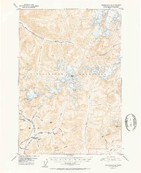
Mining operations and high mountain peaks dominate this early 1950s survey of the northern Talkeetna Mountains. The map reveals a high-altitude industrial landscape centered on the Little Susitna River and Willow Creek drainages. Hard-rock gold and mineral extraction are evidenced by a dense cluster of workings, including the Snowbird Mine, Mabel Mine, and Fern Mine, as well as several exploration sites like the Arch Prospect. The Little Susitna Roadhouse appears as a vital waypoint for travelers and miners navigating this glacial terrain. High peaks such as Montana Peak and Idaho Peak rise above the branching waters of the Kashwitna River, while the Mint Glacier highlights the active glacial processes still shaping the high valleys of Arkose Ridge.
Find a feature on this map
39 named features on this map. Tap any name to fly to it.
Don’t see what you’re looking for? This feature index may not catch every label — zoom into the map to look around manually.
Map Details
Editions of this 1952 Anchorage D-6 Map
2 editions found
Other maps of this area

1949 · Anchorage D-5
USGS Topo · 1:63,360

1949 · Anchorage D-7
USGS Topo · 1:63,360

1949 · Talkeetna Mountains A-4
USGS Topo · 1:63,360

1950 · Talkeetna Mountains
USGS Topo · 1:250,000

1950 · Anchorage D-6
USGS Topo · 1:63,360

1950 · Anchorage C-7
USGS Topo · 1:63,360

1950 · Talkeetna Mountains A-5
USGS Topo · 1:63,360

1951 · Anchorage
USGS Topo · 1:250,000

1951 · Anchorage C-6
USGS Topo · 1:63,360

1951 · Anchorage C-7
USGS Topo · 1:63,360