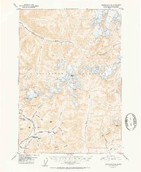
1952 Map of Anchorage D-6
USGS Topo · Published 1952About this map
The Talkeetna Mountains define the high country of this 1952 Alaskan survey, where early 20th-century mining activity and transportation routes converge along the southern slopes. The Little Susitna Roadhouse stands as a vital waypoint at the junction of the Willow Road and Fishhook Road, marking the intersection of the region's historical overland travel. To the west, a concentrated cluster of industrial sites highlights the area's geological wealth, including the Snowbird Mine, Fern Mine, and Mabel Mine. These workings, along with the Webfoot Prospect and Arch Prospect, trace the prospecting efforts that shaped the local economy.
Find a feature on this map
38 named features on this map. Tap any name to fly to it.
Don’t see what you’re looking for? This feature index may not catch every label — zoom into the map to look around manually.
Map Details
Editions of this 1952 Anchorage D-6 Map
2 editions found

Other maps of this area

1949 · Anchorage D-5
USGS Topo · 1:63,360

1949 · Anchorage D-7
USGS Topo · 1:63,360

1949 · Talkeetna Mountains A-4
USGS Topo · 1:63,360

1950 · Talkeetna Mountains
USGS Topo · 1:250,000

1950 · Anchorage D-6
USGS Topo · 1:63,360

1950 · Anchorage C-7
USGS Topo · 1:63,360

1950 · Talkeetna Mountains A-5
USGS Topo · 1:63,360

1951 · Anchorage
USGS Topo · 1:250,000

1951 · Anchorage C-6
USGS Topo · 1:63,360

1951 · Anchorage C-7
USGS Topo · 1:63,360