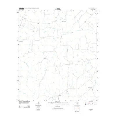
2013 Map of Ander
USGS Topo · Published 2013About this map
The community of Ander and the nearby settlement of Weser sit within a landscape defined by an intricate network of waterways and early 21st-century energy production. This rural stretch of South Texas is characterized by numerous small drainages, including Fifteenmile Cr, Eighteenmile Cr, and the colorfully named Hog Thief Cr. The presence of the Mission Valley West Gas Field and North Fannin Gas Field indicates the ongoing industrial importance of the region, while the agricultural roots remain visible through a grid of secondary roads named for local families such as Bluntzer Rd, Lassman Rd, and Baecker Rd. Local history is preserved in small, scattered burial sites like San Jose Cem, Franklin Cem, and Killebrew Cem, which offer significant value for genealogists tracing family names through the local countryside.
Find a feature on this map
46 named features on this map. Tap any name to fly to it.
Don’t see what you’re looking for? This feature index may not catch every label — zoom into the map to look around manually.
Map Details
Editions of this 2013 Ander Map
This is the sole edition of this map. No revisions or reprints were ever made.
Other maps of this area

1953 · Beeville
USGS Topo · 1:250,000

1956 · Beeville
USGS Topo · 1:250,000

1960 · Beeville
USGS Topo · 1:250,000

1962 · Fannin
USGS Topo · 1:24,000

1962 · Hensley Lake
USGS Topo · 1:24,000

1962 · Goliad
USGS Topo · 1:24,000

1963 · Meyersville
USGS Topo · 1:24,000

1963 · Weesatche
USGS Topo · 1:24,000
1963 · Yorktown East
USGS Topo · 1:24,000
1963 · Mission Valley
USGS Topo · 1:24,000