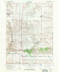
1953 Map of Andover
USGS Topo · Published 1971About this map
Jenny Lind Church stands as a significant landmark in Andover, anchor of a landscape defined by 1950s agricultural life and expanded by 1970s infrastructure updates. This map shows the rail-reliant development of Orion and Osco along the Chicago Rock Island and Pacific tracks, which bisect the northern prairie. To the south, the Edwards River and South Edwards River carve through the terrain, flanked by a network of rural education sites including Forest View School, Edwards Valley School, and Pleasant Valley School. The presence of the Home for children near Lynn Center provides a glimpse into the social services of the era. The mapping, originally completed in 1953 and revised in 1970, captures the shift from a purely agrarian economy to one increasingly interconnected by new road classifications and industrial pipelines.
Find a feature on this map
17 named features on this map. Tap any name to fly to it.
Don’t see what you’re looking for? This feature index may not catch every label — zoom into the map to look around manually.
Map Details
Editions of this 1953 Andover Map
2 editions found
Other maps of this area

1931 · Galva
USGS Topo · 1:48,000

1934 · Geneseo
USGS Topo · 1:62,500

1937 · Orion
USGS Topo · 1:62,500

1940 · Galva
USGS Topo · 1:62,500

1944 · Galva
USGS Topo · 1:62,500

1947 · Woodhull
USGS Topo · 1:62,500

1949 · Coal Valley
USGS Topo · 1:24,000
1953 · Coal Valley
USGS Topo · 1:24,000

1953 · Nekoma
USGS Topo · 1:24,000

1953 · Woodhull
USGS Topo · 1:24,000