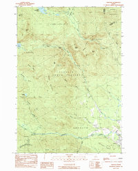
1984 Map of Andover
USGS Topo · Published 1985About this map
Andover sits at the confluence of several vital waterways in Oxford County, including the West Branch Ellis River and the Ellis River. This 1980s topographical survey documents the convergence of administrative boundaries like Andover North Surplus and C Surplus, illustrating a landscape shaped by both natural drainage and surveyor lines. The terrain is dominated by significant peaks such as Old Blue Mtn and Black Cat Mtn, while the Appalachian National Scenic Trail winds through the high ground, passing the Shelter Hall Mtn Lean-to. Local history is noted through a village Cem and The Cataracts, a distinctive water feature. The map captures a moment when timber and recreation define the area, marked by a Gravel Pit and the remote reaches of Lower Richardson Pond.
Find a feature on this map
42 named features on this map. Tap any name to fly to it.
Don’t see what you’re looking for? This feature index may not catch every label — zoom into the map to look around manually.
Map Details
Editions of this 1984 Andover Map
2 editions found
Other maps of this area

1927 · Rumford
USGS Topo · 1:48,000

1930 · Rumford
USGS Topo · 1:62,500

1933 · Rangeley
USGS Topo · 1:48,000

1939 · Rangeley
USGS Topo · 1:62,500

1940 · Oquossoc
USGS Topo · 1:62,500

1942 · Oquossoc
USGS Topo · 1:62,500

1943 · Old Speck Mtn
USGS Topo · 1:62,500

1945 · Old Speck Mtn
USGS Topo · 1:62,500

1949 · Rangeley
USGS Topo · 1:62,500

1950 · Lewiston
USGS Topo · 1:250,000
Featured Places
- Andover, ME
- Byron, ME
- Andover North Surplus Township, ME
- Andover West Surplus Township, ME
- Township C, ME