
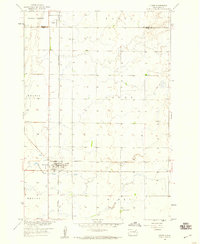
1958 Map of Andover SW
USGS Topo · Published 1960About this map
The prairie landscape of Andover and Scotland townships is defined by a sparse network of country schoolhouses and natural drainage basins. In the late 1950s, the rural character of this region is anchored by social and educational hubs such as School No 216, School No 217, and School No 219, which served the farming families of both Day and Brown counties. The topography is marked by significant water features including Amsden Lake and Pigors Lake, which, along with the meandering path of Mud Creek, dictate the movement and settlement patterns across the plains. Local industry is represented by scattered Gravel Pits, while the Scotland Cem remains a primary point of interest for those tracing family lineages in this part of South Dakota.
Find a feature on this map
14 named features on this map. Tap any name to fly to it.
Don’t see what you’re looking for? This feature index may not catch every label — zoom into the map to look around manually.
Map Details
Editions of this 1958 Andover SW Map
This is the sole edition of this map. No revisions or reprints were ever made.
Other maps of this area

1894 · Conde
USGS Topo · 1:62,500

1895 · Aberdeen
USGS Topo · 1:125,000

1953 · Milbank
USGS Topo · 1:250,000

1954 · Groton
USGS Topo · 1:24,000

1954 · Ferney
USGS Topo · 1:24,000

1954 · Aberdeen
USGS Topo · 1:250,000

1956 · Aberdeen
USGS Topo · 1:250,000

1958 · Milbank
USGS Topo · 1:250,000
1958 · Conde
USGS Topo · 1:24,000

1958 · Andover
USGS Topo · 1:24,000