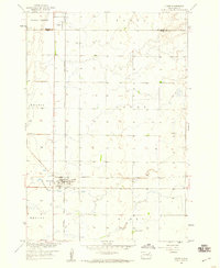
1958 Map of Conde
USGS Topo · Published 1960About this map
The town of Conde serves as a central hub in this late-1950s survey, marking a strategic junction between the Minneapolis and St Louis and Chicago and North Western railroads. Situated at the border of Brown and Spink counties, the area is characterized by the expansive Garden Prairie and the agricultural townships of Benton, Olean, and Conde. The landscape is etched with the drainage patterns of the James River basin, featuring subtle landmarks like a Flowing Well and a localized Gravel Pit. To the north, the small settlement of Verdon is documented alongside the Verdon Cem, providing essential data for genealogists tracking family roots in the glacial till plains of northeastern South Dakota during a period of established rail-dependent commerce.
Find a feature on this map
14 named features on this map. Tap any name to fly to it.
Don’t see what you’re looking for? This feature index may not catch every label — zoom into the map to look around manually.
Map Details
Editions of this 1958 Conde Map
This is the sole edition of this map. No revisions or reprints were ever made.
Other maps of this area

1894 · Conde
USGS Topo · 1:62,500

1895 · Aberdeen
USGS Topo · 1:125,000

1953 · Groton SW
USGS Topo · 1:24,000

1953 · Milbank
USGS Topo · 1:250,000

1954 · Ferney
USGS Topo · 1:24,000

1954 · Aberdeen
USGS Topo · 1:250,000

1956 · Aberdeen
USGS Topo · 1:250,000

1958 · Milbank
USGS Topo · 1:250,000
1958 · Randolph
USGS Topo · 1:24,000

1958 · Andover SW
USGS Topo · 1:24,000