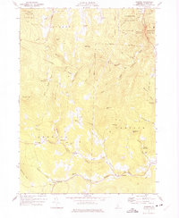
1971 Map of Andover
USGS Topo · Published 1975About this map
The Andover Branch and Middle Branch rivers carve through the central mountains of Windsor County, defining a landscape of small settlements and high hills. Simonsville, Middletown, and Andover sit along these valley floors, connected by winding roads like Lovers Lane. The map reveals a high density of rural infrastructure, including the East Hill Sch and numerous burial grounds such as Heald Cem and Simsbury Cem, reflecting the early civic development of these townships. Industrial activity is concentrated at several Gravel Pit sites and a Quarry near Whetstone Hill. The eastern portion of the quadrangle includes the Chester Reservoir and the Proctor-Piper State Forest, where the terrain rises toward Butternut Hill and Ingraham Hill. This 1970s survey captures the area just as modern forest management and recreational spaces began to balance with the long-standing agricultural and family-named landmarks that have anchored these Vermont hills for generations.
Find a feature on this map
50 named features on this map. Tap any name to fly to it.
Don’t see what you’re looking for? This feature index may not catch every label — zoom into the map to look around manually.
Map Details
Editions of this 1971 Andover Map
2 editions found
Other maps of this area

1893 · Wallingford
USGS Topo · 1:62,500

1894 · Londonderry
USGS Topo · 1:62,500

1899 · Londonderry
USGS Topo · 1:62,500

1928 · Ludlow
USGS Topo · 1:48,000

1929 · Ludlow
USGS Topo · 1:62,500

1930 · Saxtons River
USGS Topo · 1:48,000

1932 · Ludlow
USGS Topo · 1:62,500

1933 · Saxtons River
USGS Topo · 1:62,500

1950 · Glens Falls
USGS Topo · 1:250,000

1955 · Wallingford
USGS Topo · 1:62,500